


Stephen's Gap Cave System..
Stephens Gap Callahan Cave Preserve is one of the most awesome treasures in northeast Alabama. Stephens Gap Cave is a beautiful cave pit with a 143-foot waterfall falling into it with a large opening where you can hike into the pit. There are no rails around the top so be extremely careful looking into the pit. The hike is almost a mile and well worth it. So be prepared and bring plenty of water and a snack on this hike. Be very careful hiking Stephens Gap trail after a rain, may be muddy and slippery. Acreage Stephens Gap Callahan Cave Preserve is located on 123 hardwood acres. Stephens Gap is a no Drone zone! Cell phone reception is spotty at best, i would not expect service at the preserve

Stephens Gap offers great rappelling, hiking, photography, low-impact camping may be allowed on a request and case-by-case basis. While in the area be sure to visit Cathedral Caverns State Park, Fern Cave National Wildlife Refuge, and Sauta Cave National Wildlife Refuge. Stephens Gap cave in Alabama one of the most photographed caves in the US. Camping is only permitted on the bluff above the the pit and is only enough room for a couple of tents. Camping is not allowed in the parking area.

The MOST BEAUTIFUL CAVE You Have Never Heard Of
The MOST BEAUTIFUL CAVE You Have Never Heard Of..
Stephens Gap cave is no doubt one of the most magical caves in Alabama. My first trip to Stephens Gap Cave was unbelievable and completely worth the hike and drive. I was lucky to visit Stephens Gap Cave while the waterfall was falling hard and fast from the prior week of rain. Not only is Stephens Gap Cave magical but the land around the cave is breathtaking.
Above the Stephens Gap cave is a beautiful waterfall coming off the side of the mountain surrounded by hardwoods and plenty of plants and animals on the property. Stephens Gap Cave is the most relaxing and majestic cave preserves to hike in Alabama. There is something about this Stephens Gap cave that makes you want to sit and relax and let the troubles of life pass you by for a while, it is hard to leave and easy to stay for a while. Stephens Gap Callahan Cave Preserve is managed by Southeastern Cave Conservancy, Inc. and permit is required to visit the preserve.

Stephens Gap Rappel Alabama
The trail is roughly ¾ to 1 mile to the cave. The hike to the cave takes about 20-30 minutes and the trail is pretty worn. The hike is easy when the ground is dry and when it is wet there are a couple slippery spots. When you get to the cave you will see a large entrance below to the left and if you hike up past it you will see the 143-foot pit. You can hike on above the pit and see a nice waterfall and to the left is a nice overlook.
Along the trail you will also come across another small pit that is cool. I have also hiked to an old rock query to the right as you begin the trail, it is awesome and huge!
Stephens Gap Rappel Alabama

Once you have hiked the Stephens Gap Trail the entrance to Stephens Gap cave is to the bottom left. You will hike down some large rocks to the main pit, it can be slippery after a heavy rain. I have always viewed into the pit before i went into the cave. The safest place to view into the pit is to the left side where the tie off tree is located. All the other areas around the pit are sketchy at best, better to be safe than sorry.

I have visited the cave every season of the year and have found fall and springs to be a great time to visit. The winter months can be slick hiking and I have found after a good rain in the fall is a treat! If you want to get the experience of the sunshine in the pit, the earlier the better. The sun shines in the pit at Stephens Gap roughly between 8 and 10 and really depends on the time of the year.
There have been a good many fatalities at the cave over the years and there seems to be an accident every 3 or 4 years or so. Like all caves caution is necessary, Stephen's Gap can be a dangerous place to visit and quite a few people have slipped inside the pit walking on the ledges. The rocks inside the cave stay slippery from the constant waterfall. and could represent a hazard of falling..
A permit is required to hike, camp and visit the cave. Permits are limited to max group size 15 and min group size of 2. They have a quota of 25 per day and it seems like they are starting to fill up in advance . You can obtain a permit through Southeastern Cave Conservancy, Inc.

Wear real hiking boots that have good grip and not tennis shoes!
It is a pretty good hike to the cave and I highly recommend food and water!
You need to have a permit before hiking and parking. You can obtain this online and screenshot your permit on your phone, just in case. For Photography- Bring your camera and a tripod! If you are serious about a good image, I would highly recommend a tripod. I also recommend you carry a cover for your camera to keep it from getting wet. The ceiling does drip water.

DAY TRIP TO STEPHENS GAP!!!!!!!
DAY TRIP TO STEPHENS GAP!!!!!!!
Cave 2

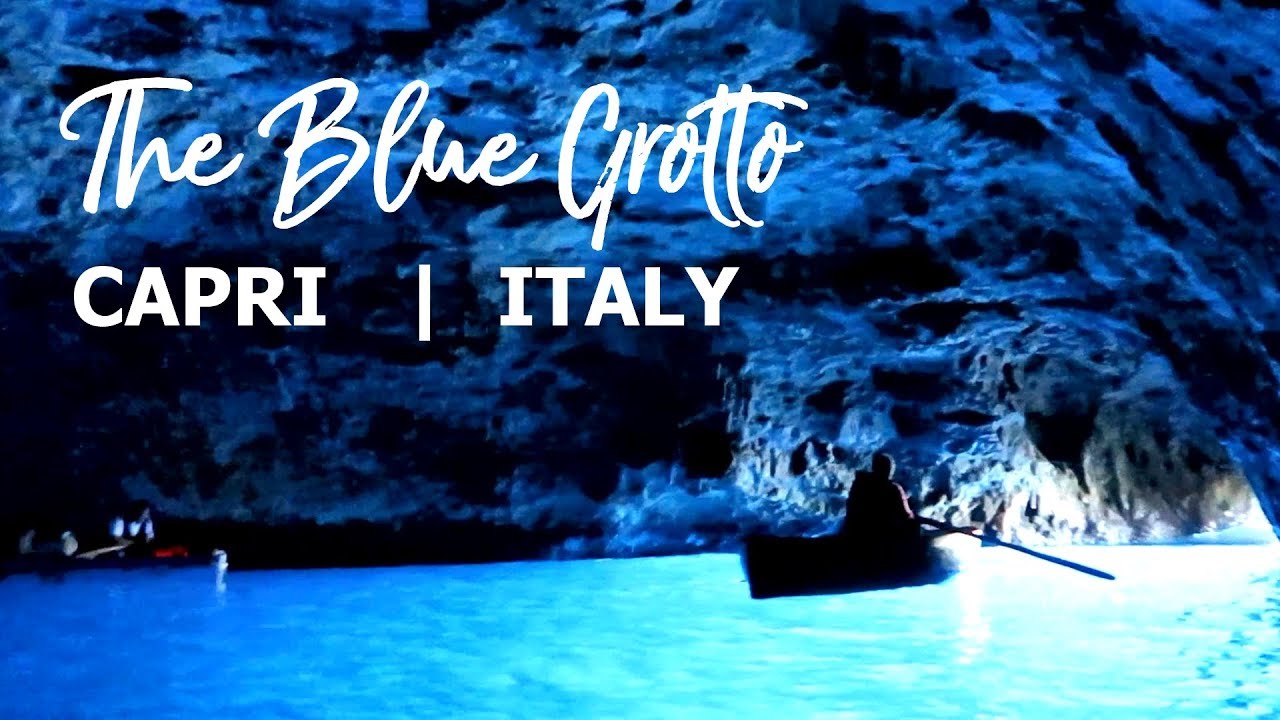
The Blue Grotto, Italy
The Blue Grotto is a sea cave on the coast of the island of Capri, southern Italy. Sunlight passing through an underwater cavity and shining through the seawater creates a blue reflection that illuminates the cavern. The cave extends some 50 metres into the cliff at the surface, and is about 150 metres (490 ft) deep, with a sandy bottom.
Blue Grotto, Capri, Italy | Grotta Azzurra, Italia
Blue Grotto, Capri, Italy | Grotta Azzurra, Italia.
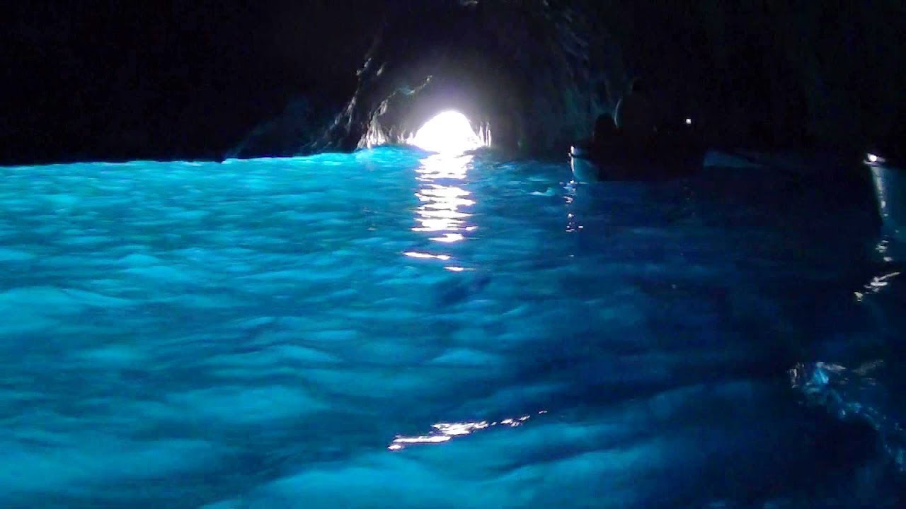
The cave is 60 metres long and 25 metres wide. The entry is two metres wide and roughly one metre high at low tide, making safe access possible only when tides are low and the sea is calm. To enter the grotto, visitors must lie flat on the bottom of a small four-person rowboat. The oarsman then uses a metal chain attached to the cave walls to guide the boat inside the grotto. In 2011 a visitor suffered a life altering injury when his neck was broken while entering the cave. The Cooperativa Battellieri Grotta Azzurra initially denied liability but settled a damages claim. It was concluded that the boatmen had continued entering the cave when the sea conditions were inappropriate. Swimming in the grotto is forbidden.

The Blue Grotto is one of several sea caves worldwide that is flooded with a brilliant blue or emerald light. The quality and nature of the colour in each is determined by its unique combination of depth, breadth, water clarity, and light source. In the case of the Blue Grotto, the light comes from two sources: the narrow arched entranceway, and an aperture approximately ten times as large directly below it, separated by a band of rock between one and two meters tall. Because it is farther from the surface much less light passes through the lower opening, but its depth and size allow it to be the grotto water's primary source of illumination.
Blue Grotto, Capri, Italy - Relaxing boat tour. Grotto Azzurra
Blue Grotto, Capri, Italy - Relaxing boat tour. Grotto Azzurra..
As light passes through the water into the cave, red reflections are filtered out and only blue light enters the cave. Objects placed in the water of the grotto famously appear silver. This is caused by tiny bubbles, which cover the outside of the object when they are placed underwater. The bubbles cause the light to refract differently than it does from the surrounding water and gives off the silver effect. In part because of the dazzling effect of the light from the above-water opening, it is impossible for a visitor who is in one of the rowboats to identify the shape of the larger hole, the outline of the bar that separates the two holes, or the nature of the light source, other than a general awareness that the light is coming up from underneath, and that the water in the cave is more light-filled than the air. A visitor who places a hand in the water can see it "glow" eerily in this light.

During Roman times, the grotto was used as the personal swimming hole of Emperor Tiberius as well as a marine temple. Tiberius moved from the Roman capital to the island of Capri in 27 AD. During Tiberius' reign, the grotto was decorated with several statues as well as resting areas around the edge of the cave.

Three statues of the Roman sea gods Neptune and Triton were recovered from the floor of the grotto in 1964 and are now on display at a museum in Anacapri..

Neptune - Roman God of the ocean..
.jpg)
Triton - God of the Sea
Seven bases of statues were also recovered from the grotto floor in 2009. This suggests that there are at least four more statues lying on the cave's bottom. The cave was described by the Roman historian Pliny the Elder as being populated with Triton "playing on a shell". The now missing arms on the recovered Triton statue – usually depicted with a conch shell, suggest that the statues recovered in 1964 are the same statues Pliny the Elder saw in the 1st century AD. According to a reconstruction of how the Blue Grotto may have looked in Roman times, a swarm of Triton statues headed by a Neptune statue may have stood in the walls of the cave. The Marevivo association aims construct this by placing statues in the grotto. This project is being carried out in collaboration with the archaeological superintendence of Pompeii..

At the back of the main cave of the Blue Grotto, three connecting passageways lead to the Sala dei Nomi, or "Room of Names", named for the graffiti signatures left by visitors over the centuries. Two more passages lead deeper into the cliffs on the side of island. It was thought that these passages were ancient stairways that led to Emperor Tiberius' palace. However, the passages are natural ones that narrow and then end further along.

Painting by German writer August Kopisch.
During the 18th century, the grotto was known to the locals as Gradola, after the nearby landing place of Gradola. It was avoided by sailors and islanders because it was said to be inhabited by witches and monsters. The grotto was then "rediscovered" by the public in 1826, with the visit of German writer August Kopisch and his friend Ernst Fries, who were taken to the grotto by local fisherman Angelo Ferraro.
The cave as in every medieval history was said to be a refuge for devils and monsters. Two priests determined to drive them away entered the cave swimming, after a few minutes spent inside it they ran away in panic as if they had seen the face of the devil. From that moment on, the two began to rant. Named the cursed cave, it preserves numerous legends.
Cave 3

Melissani Cave, Kefalonia Island, Greece.
In Greek mythology, Melissani was the Cave of the Nymphs. It features a lake surrounded with trees and forest, and is located east of the mountains of Evmorfia and Agia Dynati. The lake's bottom is covered with stones. Plants grow at the opening of the cave. The color of the stone near the opening is stucco to honey-like brown. The cave was rediscovered in 1951 by Giannis Petrocheilos.
![Melissani Cave, Kefalonia Island, Greece 🇬🇷 [TRAVEL VLOG]](https://i.ytimg.com/vi/0ear8zV5W6o/maxresdefault.jpg)
Melissani Cave, Kefalonia Island, Greece 🇬🇷 [TRAVEL VLOG]
Melissani Cave, Kefalonia Island, Greece 🇬🇷 [TRAVEL VLOG]
The Melissani Cave is located about 2km from the Sami village on the island of Kefalonia. The cave lake is one of the most popular tourist attractions on the island. On the outside, the cave is surrounded by trees and forests and on the inside, a magnificent site opens a rocky cave filled with crystal clear water. The cave has two big halls and an island in the middle. One of the halls opens on the surface and lets the light in, which makes the water so clear it seems that the boats are gliding through the air. Swimming is not allowed on Melissani lake. It’s a boat ride only. However, there are many beautiful beaches nearby. When the sun stands high above the lake it shines down through the collapsed roof to the turquoise waters of the lake. The cave is easily reachable by car from Sami or Agia Efimia. If you do not have your transport you can take a Bus.
The cave is open from May to October.
Opening hours 9:00-17:00
Boat trip takes around 15mins and the price is 7 EUR

Nymph Melissani from Greek mythology decided to end her life after being rejected by Pan, by throwing herself into the emerald lake within the cave. Today the lake and karst cave of the same name are beloved natural attractions. The cave is over 500ft long and features stalactite formations that date back thousands of years.
Cave 4

The blue ice caves of the Vatnajökull Glacier, Iceland.
Vatnajökull Region is a great place to visit one of Iceland’s natural wonders; the ice caves. The ice caves form during the winter months in the outlet glaciers of Vatnajökull, one of the biggest glaciers in Europe by volume. In the fall, professional local guides go scouting for the ice caves for the coming winter season.

ICE CAVES in Vatnajokull National Park, the south coast of Iceland 4K Ultra HD | Ice cave Iceland
ICE CAVES in Vatnajokull National Park, the south coast of Iceland 4K Ultra HD | Ice cave Iceland.
In some countries, you have almost the same ice caves year after year as the temperature there is constant. However, Icelandic caves are different. Each winter the weather cools and conditions change. Guides start looking for new caves, large and safe enough to explore on the inside.
Most of the ice caves are formed as canals for water that run through or at the bottom of the glacier. The water digs its way from underneath the glacier and forms the caves. Usually, they are formed in the summer when the flow of meltwater is at its peak. Then they are full of water and not accessible. When the shedding stops during fall, the flow of water in the cave greatly reduces and usually stops completely throughout the winter. The temperature becomes cold enough to strengthen the ice. As a result, what you have left is an ice cave.

ICELAND'S FAMOUS BLUE ICE CAVE TOUR | Vatnajökull Glacier | ICELAND SOUTH COAST | ICELAND with KIDS
ICELAND'S FAMOUS BLUE ICE CAVE TOUR | Vatnajökull Glacier | ICELAND SOUTH COAST | ICELAND with KIDS.
During the winter there sometimes are warmer periods with strong wind and rain. Then the caves are flooded with water and become dangerous and impassable. The ice caves are only accessible during winter months, from November and usually throughout March, depending on the weather. The beautiful ice caves are very dangerous if you are not accompanied by a trained guide that knows the glacier from inside out, you should not go there by yourself. The caves should never be entered without a glacier guide and proper safety gear. Before going into the ice cave with a tour operator, you are provided with a safety helmet and crampons for walking on the ice.

Blue Ice Caves at the Vatnajökull glacier in Iceland 2019
Blue Ice Caves at the Vatnajökull glacier in Iceland 2019.
The most known cave in South East of Iceland is the Crystal Cave, which is very popular among the tour companies in the area. Therefore, the cave can be a bit crowded, but still, it’s a wonderful experience to be inside and enjoy this spectacular wonder of nature. The ice cave that has been the most popular in recent years is called Crystal ice cave, because of the clearness of the ice.


Crystal Ice Cave - Iceland.